SALT RIVER
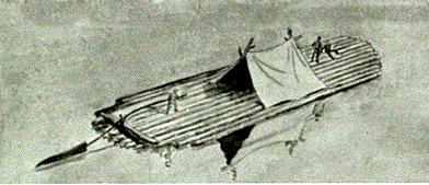
Early Flatboat
Crossing Bullitt County in a west to east direction is Salt River.
It cuts Bullitt County approximately in half. At one time all the area south
of the river was in Nelson county and the area north of the river was in
Jefferson county. Its name was derived from the river's proximity to the
Bullitt' Salt Lick. The river was referred to as the Salt Lick River. In
time the work "lick" was dropped and Salt River has remained up
to this day.
The phrase "going up Salt River", is related to a politician who
was supposed to speak to an audiance in Louisville. He was being transported
by boat up the Ohio River. Due to some one's design the boat was taken up
Salt River when the pilot reached its mouth thus causing the politician
to miss the engagement. After this, someone is "going up Salt River"
when he loses an election or fails to keep his appointed speaking engagements.
In pioneer days the river was one of the main sources for transportation.
Henry Crist and others participated in the "Battle of the Kettles"
on the river. Goods were loaded on flatboats and shipped to market. By 1790
shipments of tobacco, hemp, flour, timber and other farm produce had become
so important that inspection stations were established at the mouth of Brashear's
Creek at Taylorsville, on the land of Adam Shepherd at Shepherdsville, and
on the land of Matthew Walton about 1/2 mile below the mouth of Long Lick
Creek.
In the 1840's a group of distillers and farmers at Smithville built the
Susianna, said to be the largest produce flat boat ever to go out of Salt
River. The boat was 100 feet long, 22 feet wide and when loaded, drew 4
feet of water. On one voyage to Louisiana its cargo consisted of 225 barrels
of whiskey, 2000 bags of corn, 42 wagons of pork, 200 barrels of Irish potatoes,
in addition to un- disclosed quantities of meal, hay and oats. (Salt River
Tiger, Vol. 1, No. 6, Jan. 22, 1897).
Several times efforts have been made to improve the river for navigation.
In 1818,. the sum of $38,133 was spent to make improvements for navi- gation
on the Kentucky, Green, Salt, Cumberland, and other rivers. In 1837 and
again in 1873 surveys were made to see where dams could be located to make
the river navagatable by steamboats. Nothing was ever done to carry out
any plans to make these improvements.
With the coming of the steamboats, Pitt's Point increased in importance,
for steamboats could not ordinarily move upriver farther than a point about
4 miles below Shepherdsville. Thus Pitt's Point was the terminus for most
river packets except in time of high water. Timber, grain, hay, tobacco
and lumber were transferred at Pitt's Point to steamers and barges and transported
to markets in New Albany, Louisville, and other markets. When the water
was high, the river steamers could travel as far as Shepherdsville.
The "Salt River Tiger" gives us two accounts of steamboat movement:
Feb. 12, 1897: "The Jingo, the hustling little steamboat which plies
between Pitt's Point and Louisville, is enjoying quite a trade. it has eclipsed
all other boats in the matter of carrying goods, and it splashes around
like an elephant.'
January 7, 1897: "The little steamer Raymond, whose captain is John
Plotz, arrived in Louisville today with two barges containing 312 fine fat
hogs, another barge of lumber, and another loaded with hickory timber. In
addition, there were 42 coops of poultry, 180 barrels of apples and potatoes
and 300 bales of hay. On her trip out of Salt River last week, the Raymond
brought 152 hogs, 2 barges of lumber, a barge of hickory, a load of produce,
and eleven passengers.'
Other steamers that plied Salt River were the Mattie Hays, Market Boy, Grace
Morris, Bellview, Reindeer and Clermond. So important was the river that
in 1837 and again In 1873 the Federal Goverment made extensive surveys toward
the possibility of building a series of locks and dams to improve navigation.
The packet service continued until about 1910.
In addition to the packets which carried passengers and freight there operated,
on the river, a number of saw mill and tie boats. The Nimrod was one of
these. It burned at Pitt's Point.
The river is subject to periodic flooding. The worst flood in the history
of the county was the one that occurred in 1937.
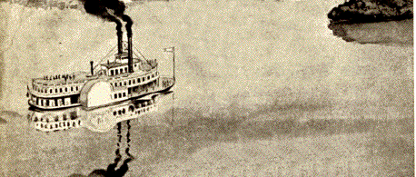
A steamer on the Ohio circa 1860's
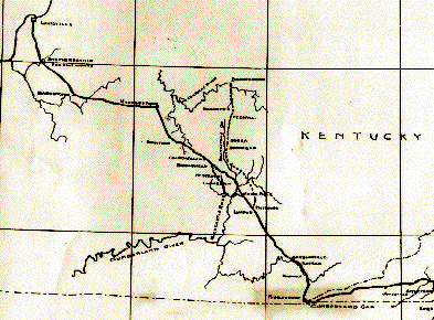
WILDERNESS ROAD
The next avenue of travel was the Wilderness Road. It primarily was a buffalo
road. That is, it was a wide path, up to 20 or more feet wide in some sections,
crea- ted by the herds of buffalo that once roamed Bullitt County and Kentucky.
Bullitt County was particularly important because of the numerous licks
to which the wild game went to get their needed salt. Historians have usually
talked about the Wilderness Road but only the section that went to Crab
Orchard, Kentucky, neglec- ting the branch that went to Louisville. This
branch is just as important to the history of Kentucky and may even more
important than the other.
As far as the county is concerned the road went through at several locations.
One of these was the ford at Shepherdsville, one at Dowdall's Garrison,
one near Floyd's Fork. Depending on the stage of Salt River, one or more
of these were followed. Once across the river they all converged into one
road that went through Bullitt's Lick and the Blue Lick Gap in the knobs.For
a more detailed treatment of the actual path of the Wilderness Road, click
here.
As population increased, more land was cleared, other roads were opened
and traveled. Some of these were stage roads linking one city with another.
U.S. 31-E Is one of these roads. It linked 31-E with Shepherdsville, presently
Highway 44. An interesting note highway 44 is the account of the construction
of the bridge over Floyd's Fork. The Kentucky Legislature passed an act
on January 23, 1813 that authorized the citizens of Bullitt County to build
this bridge. Guy Phelps, John McDowell, Joseph Hough, Joshua Norvell, and
James Burk were appointed comissioners, authorized to construct the bridge.
It was to be a toll bridge and the rates were as follows; "For every
person 6 1/4 cents; for every horse, mare or mule 6 1/4 cents; for every
carriage or cart with two wheels, 25 cents; for every carriage of wagon
with four wheels, 50 cents; for every head of neat cattle, 3 cents; and
for every hog, I cent."
Until the later 1950's other than the railroad the main links between Louisville
and Bullitt County was highway 31-E, Highway 61 (Preston Street) and to
some extent highway 31-W. In the latter 50's the Kentucky Turnpike was constructed
with an interchange constructed at Shepherdsville. Like the railroad, the
Turnpike (1-65) traverses the county from north to
outh. It has made Louisville closer to the county and many Bullitt County
citizens travel it daily.
THE L&N RAILROAD
The Louisville & Nashville Railroad maintained approximately 30 miles
of track in Bullitt County' Kentucky, and many of its trains cross the area
each day. The L&N's main line ran between Cincin- nati, Ohio, via Louisville
to New Orleans, and covered a distance of almost 20 miles in the county,
entering at a point just south of Coral Ridge, Kentucky, passing through
Shepherdsville and making its exit about a mile South of Lebanon Junction.
In addi- tion, there are two important branch lines in the county. One was
the Bardstown Branch that diverges from the main line at Bardstown Junction,
and extended some seven and a half mile in a southeasterly direction before
reaching the Nelson Countyline en route to Bardstown. The other was the
Lebanon Branch that leaves the main line at Lebanon Junction and extends
approximately three miles before it leaves the county in the direction of
Lebanon.
The L&N was a part of Bullitt County almost since the railroad was chartered
in 1850. As early as 1851, L&N survey crews crossed the county looking
for an appropriate location for the new railroad's right of way. That original
survey party consisted of: L. L. Robinson, Col. William Riddle, Joshua Bullitt
and S. B. Thomas. They laid out an area 66 feet wide through the center
of which would be constructed the "main stem" of the Louisville
& Nashville Railroad. Construction of the new line began at 9th and
Broadway in Louisville, May 2, 1853, and reached Bullitt County sometime
in 1854; the exact date is not on record. Cost was $35,000 per mile.
The Bardstown Branch was chartered as the Louisville & Bardstown Railroad
and built by the
citizens of Nelson County at a cost of $300,000. This 18-mile line was completed
in 1860 and was operated by the L&N for four years prior to becoming
part of the system during the Civil War years. Work on the Lebanon Branch
was begun in 1854, the first rail was laid in 1855, and the line was completed
in November 1857. Trains did not begin operating over the new track until
March 8,
1858.
The L&N had been in operation less than five years when the Civil War
began. At the time no one realized just how important the young railroad
was around the world, and the commodities these railroads hauled reached
every household in their territory just about every day.
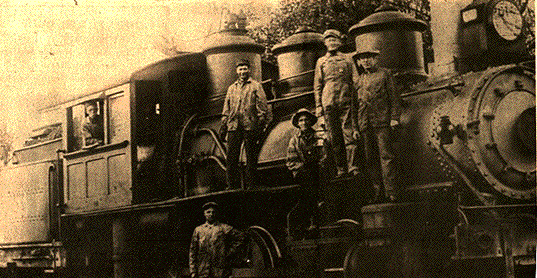
The L&N in Lebanon Junction